


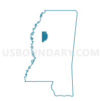
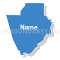
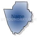
Money Voting District, Leflore County, Mississippi
About
Outline

Summary
| Unique Area Identifier | 606081 |
| Name | Money Voting District |
| County | Leflore County |
| State | Mississippi |
| Area (square miles) | 97.13 |
| Land Area (square miles) | 94.14 |
| Water Area (square miles) | 2.98 |
| % of Land Area | 96.93 |
| % of Water Area | 3.07 |
| Latitude of the Internal Point | 33.62936720 |
| Longtitude of the Internal Point | -90.20175070 |
Maps


Graphs
Select a template below for downloading or customizing gragh for Money Voting District, Leflore County, Mississippi


Neighbors
Neighoring Voting District (by Name) Neighboring Voting District on the Map
- Holcomb Voting District, Grenada County, MS
- Minter City Voting District, Leflore County, MS
- North Greenwood Voting District, Leflore County, MS
- Northeast Greenwood Voting District, Leflore County, MS
- Philipp Voting District, Tallahatchie County, MS
- Ray's Shop Voting District, Carroll County, MS
Top 10 Neighboring County Subdivision (by Population) Neighboring County Subdivision on the Map
- District 2, Leflore County, MS (6,617)
- District 1, Leflore County, MS (6,139)
- District 5, Grenada County, MS (4,850)
- District 2, Carroll County, MS (2,475)
- District 4, Tallahatchie County, MS (1,858)
Top 10 Neighboring Place (by Population) Neighboring Place on the Map
Top 10 Neighboring Unified School District (by Population) Neighboring Unified School District on the Map
- Grenada School District, MS (21,906)
- Greenwood Public School District, MS (16,223)
- Leflore County School District, MS (16,094)
- Carroll County School District, MS (10,597)
- West Tallahatchie School, MS (7,096)
Top 10 Neighboring State Legislative District Lower Chamber (by Population) Neighboring State Legislative District Lower Chamber on the Map
- State House District 46, MS (21,810)
- State House District 32, MS (21,738)
- State House District 34, MS (21,017)
- State House District 30, MS (19,921)
Top 10 Neighboring State Legislative District Upper Chamber (by Population) Neighboring State Legislative District Upper Chamber on the Map
Top 10 Neighboring 111th Congressional District (by Population) Neighboring 111th Congressional District on the Map
Top 10 Neighboring Census Tract (by Population) Neighboring Census Tract on the Map
- Census Tract 9502, Grenada County, MS (5,492)
- Census Tract 9506, Leflore County, MS (5,238)
- Census Tract 9501, Carroll County, MS (4,938)
- Census Tract 9502, Leflore County, MS (3,030)
- Census Tract 9504, Tallahatchie County, MS (2,786)
- Census Tract 9501, Leflore County, MS (1,113)